This website uses cookies, which are small text files that the website puts on your device to facilitate operation. Cookies help us provide a better service to you. They are used to track general user traffic information and to help the website function properly.
Starting Places (16) in area South East Midlands: Ballinvarry West, Clodiagh Church, Coolnahau, Coppanagh Wood South, Freney's Well, Glynn, Gorlough Wood, Hill of Allen, Inistioge, Killamery Wood East, Kylebeg Wood, Lingaun River, Mount Alto Wood, Mullenbeg Wood South, Newtown Upper School, Slievenamon Walk Head
Summits & other features in area South East Midlands: E: Barrow: Clogrennan Hill 336m, Newtown Hill 208m N Cen: Timahoe Hills: Ballaghmore Hill 268m, Cullenagh Mountain 317m, Fossy Mountain 332m, Hewson Hill 261m N: Croghan: Croghan Hill 234m N: Newbridge Hills: Dunmurry Hill 233m, Hill of Allen 219m S: Mullinavat: Coolnahau Hill 265m, Corbally Hill 285m, Mount Alto 276m, Tory Hill 292m S: Slievenamon: Knockahunna 502.8m, Sheegouna 553.5m, Slievenamon 720.2m, Slievenamon North-West Top 564m S: Windgap: Carricktriss Gorse 314m, Carrigadoon Hill 296.9m, Faranaree Hill 283m SE: Brandon Hill: Brandon Hill 515m, Coppanagh 365m, Croghan 365m W Cen: Durrow: Ballynalacken Hill 314m, Caponellan Hill 253m, Knockmannon Hill 315m W Cen: Slieveardagh: Clomantagh Hill 349m, Knocknamuck 340m, Monabrogue 284m W: Horse & Jockey: Kill Hill 241m, Killough 235m
Note: this list of places may include island features such as summits, but not
islands as such.
Knocknamuck, 340mHill Cnoc na Muc A name in Irish,
Place Rating ..
(prob. Ir. Cnoc na Muice or Cnoc na Muc [PDT], 'hill of the pig or pigs'), Tipperary County in Munster province, in Binnion Lists, Knocknamuck is the 1075th highest place in Ireland.
Grid Reference S31756 54923,
OS 1:50k mapsheet 67 Place visited by: 38members, recently by: Moirabourke, Arcticaurora, Pepe, Oscar-mckinney, Jai-mckinney, Carolyn105, markwallace, TippHiker, Taisce, chelman7, LiamG1951, sarahryanowen, dregish, magnumpig, TommyV
I visited this place: NO (You need to be a logged-in member for this.)
Longitude: -7.531587, Latitude: 52.64496, Easting: 231756, Northing: 154923,
Prominence: 268m, Isolation: 9km ITM: 631699 654964 Bedrock type: Sandstone, shale, fireclay, coal seams, (Lickfinn Coal Formation) Notes on name: Knocknamuck is the highest point in Slieveardagh.
Short or GPS IDs, 6 char: Knc340, 10 char: Kncknmck Linkback: https://mountainviews.ie/summit/912/
Gallery for Knocknamuck (Cnoc na Muc) and surrounds
Summary
for Knocknamuck (Cnoc na Muc):
Zero charm, infinite views
Summary created by wicklore
2010-07-25 02:13:00
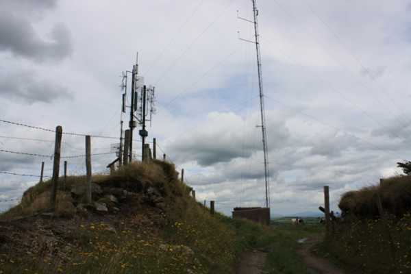
Picture: The exciting summit of Knocknamuck
Knocknamuck is not a pretty summit with several aerials, guy wires, and a concrete hut complete with security camera at the summit. It can be reached via the brief access track starting at A (S31527 54926). Other approaches are not advised due to extensive electric fencing in the fields surrounding the summit.
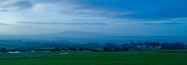
What Knocknamuck lacks in charm it more than makes up for in the expansive views it offers. It is possible to see the Comeraghs, the Galtees, the Knockmealdowns, Slievenamon, the Shannon Hills, the Slieve Blooms, the Wicklow Mountains, the Blackstairs Mountains and some of the South Midlands hills. These views make the detour to Knocknamuck worthwhile.
Picture: Slievenamon to the south through the early morning mists
jackill on Knocknamuck
by jackill
17 Jan 2010
Knocknamucks summit is reached via 250 meters of access track (A (S31527 54926) is the start point) for some television deflectors.The summit area is decorated by a green agricultural trailer sporting two masts set in a block of concrete.Not the most inspiring I agree but look south to Slievenamon from here, theres always something in a mountainview to please. Linkback: mountainviews.ie/summit/912/comment/4360/
Read Less
Read More
Summit of the Slieveardagh Hills
by Wilderness
21 May 2018
If you fancy a longer walk you can start at the car park just outside Grange at B (S309 566). From here I walked clockwise round the Crag Forest Loop until I reached the Wellington Monument. I then joined the country road which led me south towards Knocknamuck. There are a number of wind turbines scattered at the top along with some small transmitters. I highly recommend you start this walk from the Grange car park as the forest was beautiful and full of wildlife ; the Wellington Monument is definitely worth a visit too. Linkback: mountainviews.ie/summit/912/comment/19931/
Read Less
Read More
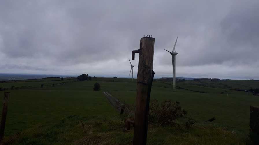
Picture: The summit?
Usain Bolt.
by TommyV
18 Mar 2019
This is purely for a quick bag. Accessed via the road mentioned in other comments. The area is now a small windfarm and there are signs at the access gate stating no unauthorized personnel. As the summit is only about 200 metres from the gate on a good track, a quick dash will have you up and down before anybody will notice. Hard to enjoy the views when you no you are deliberately trespassing but a nice quick bag all the same. Linkback: mountainviews.ie/summit/912/comment/20457/
Read Less
Read More
Tipp Mt Haven
by eamonoc
18 Sep 2013
Easily ascended Knocknamuck from point (Point A) A (S31527 54926) via good path, it took 9mins 30seconds from car to car. Not much to say except that the views in all directions were fantastic, directly south Slievenamon, the Comeraghs, to the west the Devils bit and all its attendant sattelites, southwest the Galtees and the Knockmealdown Mts, Tipperary is a Mt Haven, to the east the Blackstairs. Thanks once again Mt Views Linkback: mountainviews.ie/summit/912/comment/15188/
Use of MountainViews is governed by conditions and a privacy policy.
Read general information about the site. Opinions in material here are not necessarily endorsed by MountainViews.
Hillwalking is a risk sport. Information in comments, walks, shared GPS tracks or about starting places may
not be accurate for example as regards safety or access permission. You are responsible for your safety and your permission to walk.
See the credits and list definitions.


 Our Facebook page.